Nikolay A. Makarov*, Olga V. Zelentsova*, Dmitriy S. Korobov*, Alexander P. Chernikov**, Aleksey N. Voroshilov*
* Institute of Archaeology of RAS, Moscow (nmakarov10@yandex.ru, olgazelentsova2010@yandex.ru, dkorobov@mail.ru, voroshilov.aleksej@yandex.ru)
** TENZOR-TELECOM LTD, Moscow(Chernikov@tt-com.ru)
 Keywords: protection of archaeological heritage, Geographic Information Systems (GIS), databases, archaeological sites, archive materials, fieldwork reports, spatial analysis
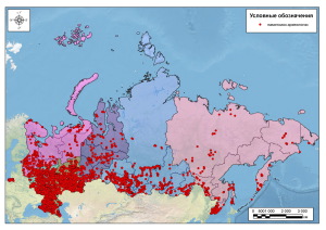
This paper summarizes the work at the creation of the first national-scale GIS ‘The Archaeological Sites of Russia’. A system of description of archaeological sites and location of trial trenches in the form of Terek, an automatic system of information proceeding with provision for computer-aided mapping was elaborated within the ranges of the project of the Russian Scientific Foundation no. 14–1803755. As of present it includes the data on 15 367 objects of archaeological heritage and 11 230 trial trenches not containing cultural deposits or any indications of the presence of ancient monuments in the relevant areas taken from reports of 2009–2012. The paper examines spatio-chronological distribution of the existing information over the entire territory of the Russian Federation. The data are indicative, on the one hand, of the degree of reclamation of vast areas in different periods and the interest of researchers to the antiquities pertaining to certain time spans in different regions manifested in the choice of fieldwork objects, on the other.


